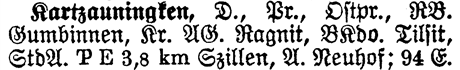
| Volume | 1 |
| Page | 936 |
| Type | D. |
| Lvl I | Pr. |
| Prov | Ostpr. |
| RB | Gumbinnen |
| Kr | Ragnit |
| AG | Ragnit |
| BKdo | Tilsit |
| StdA | Szillen |
| A | Neuhof |
| Population | 94 |
Type D. - Kartzauningken is a Dorf (Village).
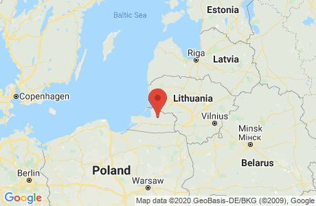
Lvl I Pr. - Level I shows which Kingdom or State the place is located in. Kartzauningken is located in Preussen.
Prov Ostpr. - The Province shows which Province or State the place is located in. Kartzauningken is located in Ostpreussen.
RB Gumbinnen - The Regierungsbezirk for Kartzauningken is Gumbinnen. The Regierungsbezirk is a government district that is in hierarchy between the State and Kreis level.
Kr Ragnit - The Kreis for Kartzauningken is Ragnit. A Kreis is a government district (similar to a U.S. county).
AG Ragnit - The Amtsgericht for Kartzauningken is in Ragnit. The Amtsgericht is where the Lower District Court is located.
BKdo Tilsit - The Bezirkskommando for Kartzauningken is in Tilsit. The Bezirkskommando is the District Military Command. You can look in the BKdo to find military records.
StdA Szillen - The Standesamt for Kartzauningken is in Szillen. The Standesamt is where the Civil Registration Office is located.
A Neuhof - The Amtsbezirk for Kartzauningken is Neuhof. The Amtsbezirk is the District Office.
The Protestant Parish is Szillen
*Source: Family Search
The list below are those places from the Meyers Gazetteer that are nearby to Kartzauningken
(which may include itself) and are listed as containing a Catholic Church or Parish,
a Protestant Church or Parish, a Synagogue, or Other Church.
| Place | Distance (~miles) | Catholic | Protestant | Jewish | Other | ||
|---|---|---|---|---|---|---|---|
| Parishes | Churches | Parishes | Churches | Synagogues | |||