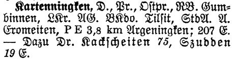
| Volume | 1 |
| Page | 936 |
| Type | D. |
| Lvl I | Pr. |
| Prov | Ostpr. |
| RB | Gumbinnen |
| LKr | Tilsit |
| AG | Tilsit |
| BKdo | Tilsit |
| StdA | Gromeiten |
| A | Gromeiten |
| Population | 207 |
Type D. - Kartenningken is a Dorf (Village).
Lvl I Pr. - Level I shows which Kingdom or State the place is located in. Kartenningken is located in Preussen.
Prov Ostpr. - The Province shows which Province or State the place is located in. Kartenningken is located in Ostpreussen.
RB Gumbinnen - The Regierungsbezirk for Kartenningken is Gumbinnen. The Regierungsbezirk is a government district that is in hierarchy between the State and Kreis level.
AG Tilsit - The Amtsgericht for Kartenningken is in Tilsit. The Amtsgericht is where the Lower District Court is located.
BKdo Tilsit - The Bezirkskommando for Kartenningken is in Tilsit. The Bezirkskommando is the District Military Command. You can look in the BKdo to find military records.
StdA Gromeiten - The Standesamt for Kartenningken is in Gromeiten. The Standesamt is where the Civil Registration Office is located.
A Gromeiten - The Amtsbezirk for Kartenningken is Gromeiten. The Amtsbezirk is the District Office.

The list below are those places from the Meyers Gazetteer that are nearby to Kartenningken
(which may include itself) and are listed as containing a Catholic Church or Parish,
a Protestant Church or Parish, a Synagogue, or Other Church.
| Place | Distance (~miles) | Catholic | Protestant | Jewish | Other | ||
|---|---|---|---|---|---|---|---|
| Parishes | Churches | Parishes | Churches | Synagogues | |||